Historical Documents from World War II
Air Navigation
Published by the Army Air Forces Training Command Visual Training Department, from technical material furnished by the Army Air Forces Instructors School (Navigator), Selman Field, Monroe, Louisiana. To be used in conjunction with current AAF Training Command memorandum covering Advanced Navigation Training.
This textbook was used to teach advanced navigation at San Marcos Army Air Field in 1944 and 1945. It is extensively illustrated with diagrams to explain virtually all material covered in the text.
Authors:
- none listed
Published:
- Army Air Forces Training Command, circa 1944
Categories:
- Navigation
- Training
Special Features:
- Owner - Includes the name of the original owner
Locations:
- Selman Field; Monroe, Louisiana, USA
- San Marcos Army Air Field; San Marcos, Texas, USA
Contributors:
- Mike Voisin
Repositories:
- Private Collection
Collections:
- John E. Voisin
Direct Link (Item 000198):
- https://aafcollection.info/items/list.php?item=000198
Citation:
- Army Air Forces Collection, "Air Navigation" (item 000198), AAF Collection, https://AAFCollection.info/items/list.php?item=000198 (accessed 26 April 2024).
Added: September 21, 2009
 |
This is the complete document, including the sections detailed below, and except for the fold-out star charts before the inside back cover.
29Mb |
 |
Front matter, chapter outlines and back matter The book does not have a table of contents or index. However each section has its own outline of the material covered. This section has the front and back covers, the title page and introduction. It also combines the pages of outlines from each section.
|
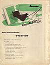 |
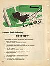
Section 1: Basic Dead-Reckoning Basic Ideas in Dead-Reckoning: The earth; The coordinate system of locating points on the earth; Direction on the earth; Linear distance on the earth. Tools Used in Basic Dead-Reckoning: Lambert conformal chart; Map reading; Plotting on the Lambert conformal chart; Time-speed-distance problems: arithmetic, computer, and table solutions. Basic Dead-Reckoning Techniques: Pre-flight preparation; Determination of groundspeed (GS); Calculations of estimated time of arrival (ETA); Correction for off-course. Basic Dead-Reckoning Procedure: Pre-flight procedure; Procedure at take-off; Keeping station; Procedure at check-points; Procedure to correct for off-course; Procedure at destination; Close-out procedure.
|
 |
Section 2: Precision Dead-Reckoning Basic Ideas and Tools of Precision Dead-Reckoning: Headings (horizontal position); Altitude (vertical position); Airspeed and groundspeed; The effect of the wind. Charts For Precision Dead-Reckoning: The Mercator plotting sheet; The Lambert conformal and other charts for precision dead-reckoning. General Techniques Employed in Precision Dead-Reckoning: Vector solutions; Keeping up with altitude; Keeping up with heading, airspeed, and air position (keeping the airplot); Keeping up with the effect of the wind; Keeping up with track, groundspeed, and ground position (keeping the ground plot); Using the airplot and the ground plot for ETA's, etc. Precision Dead-Reckoning Procedure: Chart work: airplot, ground plot, combinations; The log. Specialized Techniques in Precision Dead-Reckoning: Determination of instrument and installation error; Groundspeed by timing; Controlled groundspeed; Fuel consumption charts; Great circle routes; Patrol and search; Interception; Radius of action to same or alternate base.
|
 |
Section 3: Lines of Position, Bearings, and Fixes The Need for Checking Dead-Reckoning: Reliability of dead-reckoning depend upon accuracy of calculations; Need for checking dead-reckoning calculations by observations; The idea of origins. The Line of Position (LOP): Basic idea and examples; Kinds of LOP's; Types of LOP's; Advancing an LOP. Bearings: Basic idea and measurement of bearings; True, magnetic, and compass bearings; Relative bearings; Relations between true and relative bearings; Reciprocal bearings and LOP's. The Fix: True fix: intersection of two or more simultaneous LOP's; Running fix by advancing one or more LOP's; Order of taking LOP's for fix; course line to advance to speed line; Spacing LOP's to get good cut; Fix from three LOP's; Combining various kinds of LOP's to get a fix. Plotting and Labeling LOP's and Fixes: Plot LOP's to be advance as broken lines; Plot LOP's establishing a fix as solid lines; Labeling LOP's; Indicating and labeling fixes. Aircraft Instruments For Measuring Bearings: Driftmeter; Compass; Astro-compass; Radio instruments; Celestial instruments; Leading or trailing edge of wing, etc.
|
 |
Section 4: Supplementing Dead-Reckoning by Radio The Radio Line of Position: The instruments and their use; Obtaining the uncorrected radio bearing; Converting uncorrected radio bearing to radio line of position; The radio fix and log; Other radio and communication equipment in the aircraft. Additional Radio Aids: Radio range stations; Marker beacons.
|
 |
Section 5: Supplementing Dead-Reckoning by Celestial Observations Obtaining the Line of Position: Basic ideas; Solving for azimuth and intercept; Plotting the line of position; Classifying lines of position. Using Lines of Position in Simple Problems: As a check; The landfall. Some of the Theory Behind the Line of Position: The celestial sphere; The heavenly bodies; Time and the chronometer. Using the Line of Position in More Complex Problems: Latitude by meridianal altitude; Compass correction; Pre-computation; Position-finding: the fix.
|
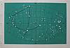 |
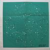
Appendix: Star Charts The book has seven pages of fold-out star charts that appear after the last page of the last section and before the inside back cover. Due to their larger size, they are provided here in two separate sections. This section contains five charts, each depicting 65 degrees north to 65 degrees south declination.
0.6Mb |
 |
Appendix: Star Charts (Continued) This section contains two star charts, a north polar projection, and a south polar projection, each depicting 10 degrees to 90 degrees declination.
0.4Mb |
|
|
Army Air Forces Collection Item 000198 is licensed by Mike Voisin under a Creative Commons Attribution-NonCommercial-ShareAlike 4.0 International License. |
